A weak shortwave is forecast to bring isolated dry lightning to the Sierra Nevada and nearby mountain ranges, with fire weather watches in parts of Northern California and red flag warnings in western Nevada.
Dry lightning is entering the Northern California forecast as a weak shortwave moves into the region, raising the risk of new wildfire starts across the Sierra Nevada and nearby mountain ranges.
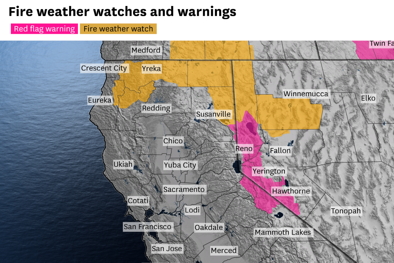
Fire weather watches are in effect for parts of the northern Sierra Nevada, southern Cascades, Trinity Alps and Klamath Range. In western Nevada, red flag warnings are also in place as forecasters warn that lightning on dry fuels could produce multiple ignitions and fast-moving fires.
The concern is centered on a short-lived setup expected to move through Thursday into Friday. Forecasters say the system could bring isolated dry lightning to the northern and central Sierra Nevada, including the Tahoe area, before shifting the focus of storm activity back toward the mountains.
By Friday morning, the disturbance may be strong enough to trigger lightning in the northern Sacramento Valley before dawn. Later in the day, thunderstorms are expected to retreat into mountainous areas, where lightning could become more frequent.
Why forecasters are worried
The National Weather Service warning cited in the reporting says dry lightning on dry fuels can create multiple fire starts and spread rapidly. That risk is especially important in steep or remote terrain, where initial attack can be difficult and a small ignition can grow quickly.
This week’s threat is arriving during an unusually vulnerable stretch of the season. Snow melted earlier than normal, and the first half of 2026 was among the warmest on record in Northern California. That combination has left higher-elevation fuels drier than usual for mid-June.
Dry lightning is different from wetter thunderstorms because it can strike vegetation without bringing much rain to the ground. In a mountain fire environment, that means the storm can create ignition points without offering the kind of moisture that would help limit spread.
The Sierra Nevada is a familiar dry-lightning risk area later in the summer, but forecasters say this setup is arriving early enough to warrant close attention. The shortwave is expected to be brief, but the timing overlaps with already dry fuels and active fire weather headlines.
What areas are being watched
The fire weather watches cover parts of the northern Sierra Nevada, southern Cascades, Trinity Alps and Klamath Range. Those are the zones where isolated strikes could be most concerning because of terrain, access and fuel conditions.
Western Nevada is under red flag warnings as well. The warnings reflect the same basic hazard: lightning in dry country can produce new starts faster than crews can reach them.
The Bay Area is not expected to face critical fire weather from this system. Forecasters do expect the storm to deepen the marine layer, which could keep coastal areas cloudy and drizzly while the more serious fire-weather setup stays inland.
That leaves the main threat concentrated across mountain and foothill terrain, where thunderstorms can form, shift and weaken quickly. The exact placement and timing remain uncertain, especially around the Friday morning window.
What happens next
Forecasters will be watching whether the shortwave actually verifies with lightning in the warned zones, and whether any strikes lead to new smoke reports or fire starts before the system exits.
They will also be tracking how far south and east the thunderstorms spread before tapering off, and whether the mountain storm activity becomes more frequent later Friday. Any new ignitions in steep terrain could quickly become a firefighting concern if winds and fuels cooperate.
The broader signal is familiar for the region: late-spring and early-summer dry lightning can be a major wildfire trigger in Northern California when snowpack has already melted early and hot weather has dried the landscape ahead of schedule.
Revision note
Initial automated publication.