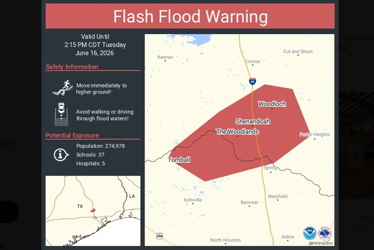
The National Weather Service extended a flash flood warning for parts of Montgomery and northern Harris counties until 2:15 p.m. Tuesday after several inches of rain caused dangerous flooding, road closures and high-water calls in the north Houston suburbs.
The National Weather Service extended a flash flood warning for parts of Montgomery County and northern Harris County until 2:15 p.m. Tuesday as thunderstorms continued to dump heavy rain across the north Houston suburbs.
The warning covered communities including Tomball, The Woodlands, Spring, Oak Ridge North, Shenandoah, Woodloch, The Woodlands Pavilion, Chateau Woods and Hooks Airport. Houston Chronicle reported that local law enforcement told forecasters some affected areas had already received 3 to 6 inches of rain by about 12:50 p.m. Tuesday.
Forecasters said rainfall rates could reach about a quarter-inch to three-quarters of an inch per hour, with as much as 2 more inches possible in the warned area.
Roads flooded across the north suburbs
Heavy rain quickly made roads dangerous in Montgomery County, where the sheriff's office reported multiple high-water incidents and warned drivers not to enter flooded areas.
Montgomery County Precinct 3 Commissioner Ritch Wheeler said Lake Woodlands Drive, Research Forest Drive and Woodlands Parkway were impassable. In Harris County, Precinct 4 Constable Mark Herman said water covered westbound lanes of Texas 99 near Gosling Road and that his office was responding to multiple high-water calls.
The Woodlands saw severe street flooding, submerged vehicles and emergency closures as water pooled in low-lying and urban areas. The flooding also disrupted travel for commuters moving through the north Houston suburbs.
Closures and local response
Local impacts went beyond the roads. Officials suspended the Town Center Trolley and closed several recreation sites as flooding spread through neighborhoods and business areas.
The response from county officials focused on keeping drivers away from flooded streets and away from water-covered intersections, where conditions can change quickly and vehicles can stall or become trapped.
Earlier in the day, a separate flash flood warning also covered parts of Liberty, Montgomery and San Jacinto counties until 1:30 p.m., including Cleveland, Splendora, North Cleveland and Porter Heights. That warning showed how the heaviest rain was shifting and expanding across the region as the storm system moved through Southeast Texas.
Broader Gulf Coast threat
The flooding in north Houston was unfolding alongside a larger Gulf Coast weather threat. AP reported that the same rain system could become the first named tropical storm of the 2026 Atlantic hurricane season and could keep producing life-threatening flash and urban flooding along the Texas coast and beyond through Thursday.
AP said Houston remained under a flood warning Tuesday and that no plans had been announced to move or reschedule the World Cup match scheduled there Wednesday. Axios also reported that Houston officials were preparing for the weather threat, including lowering Lake Houston and staffing up for emergencies.
What happens next
Forecasters will be watching whether the flash flood warning is extended again, upgraded or canceled as rain bands continue to move through the area. Officials are also watching for more road closures, rescue calls and facility shutdowns if the same neighborhoods take on additional rainfall.
The broader question is whether the Gulf disturbance strengthens into a named tropical storm and changes the rainfall forecast for Southeast Texas later in the week. For now, the immediate message from local officials is unchanged: avoid flooded roads, expect rapidly changing conditions and keep monitoring alerts.
Revision note
Initial automated publication.