Houston and much of Southeast Texas are under a Flood Watch through Wednesday morning as repeated rounds of heavy rain and thunderstorms could bring street flooding, rapid rises in bayous and localized high totals.
Houston and much of Southeast Texas are under a Flood Watch through Wednesday morning as forecasters warn that repeated rounds of heavy rain could trigger street flooding, rapid rises in bayous and flooding in low-lying areas.
The watch covers the Houston metro area and more than two dozen counties, including Harris, Fort Bend, Montgomery, Brazoria and Galveston, according to Houston Chronicle reporting based on National Weather Service guidance.
Forecasters expect 2 to 4 inches of rain across the watch area, with isolated totals of 6 to 8 inches possible where storms repeatedly track over the same places. Rainfall rates could reach 2 to 4 inches per hour at times.
The main risks are urban flooding on roads, fast rises in creeks and drainage channels, and water problems in neighborhoods that sit low or drain poorly. The setup calls for multiple rounds of heavy rain and thunderstorms rather than a single storm burst.
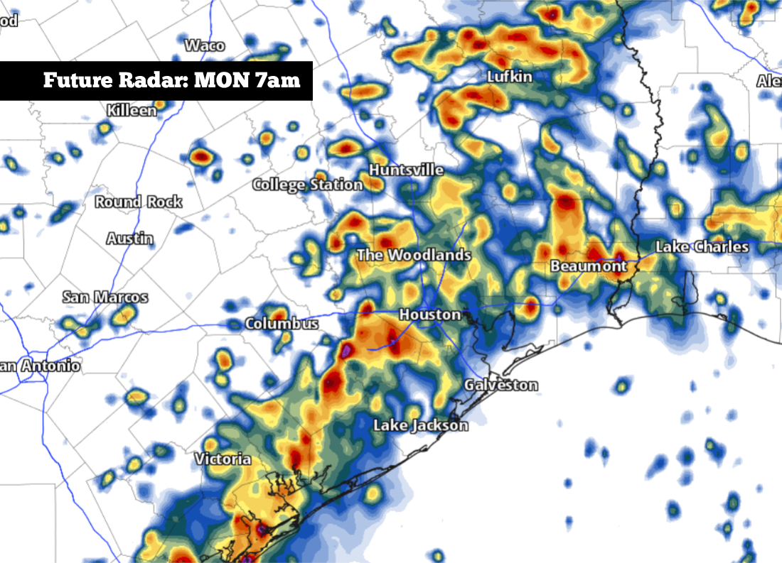
Watch and timing
The Flood Watch was posted Sunday afternoon and remains in effect through Wednesday morning, June 17. That window covers several days of potentially disruptive weather across the Houston area and surrounding Southeast Texas counties.
Officials and forecasters are treating the event as a multi-round rain threat, which matters in a city where heavy rainfall can quickly overwhelm bayous, drainage systems and major roadways. Even if the rain falls in waves rather than all at once, the cumulative effect can still create flooding problems.
How the threat built
Earlier Sunday, the Houston Chronicle reported that a wetter pattern was setting up for the region, with heavy tropical downpours expected as a stalled front interacted with deep Gulf moisture. That report said Southeast Texas was already under a Level 2 of 4 risk for excessive rainfall Sunday and Monday.
Later in the day, Chron reported that the National Hurricane Center was monitoring a disturbance in the northwestern Gulf with a 20% chance of development over seven days. The system is not the immediate cause of the Flood Watch, but forecasters said it could further increase rain chances along the Texas coast.
By 6:03 p.m. UTC Sunday, the Flood Watch was in place for Houston and much of Southeast Texas. That was the first materially confirmed alert in the evolving weather setup, turning earlier rain concerns into an active flood threat.
Areas at risk
The watch area includes Harris County and surrounding counties across Southeast Texas, with the Houston metro at the center of the concern. Houston Chronicle reporting says the watch reaches more than two dozen counties in all.
The biggest concerns are in places that flood easily: low-lying neighborhoods, streets with poor drainage, and waterways that respond quickly to repeated heavy rain. Rapid rises in bayous and creeks are possible if storm bands keep training over the same corridor.
Travel and daily routines may also be affected. Commuters could face ponding on roads, slowed traffic and isolated closures if water rises faster than drains can handle it. Outdoor plans and coastal travel may also be disrupted by the repeated storm pattern.
What to watch next
Forecasters will be watching whether the Flood Watch is expanded, upgraded or replaced by flood warnings if rainfall intensifies. The most important near-term question is where the heaviest bands set up and whether repeated storms produce localized higher totals.
Residents should keep an eye on updated National Weather Service guidance and county-by-county impacts through midweek. The immediate risk is not just total rainfall, but how quickly the rain falls and whether storms keep returning to the same places.
For now, Houston and much of Southeast Texas face a classic warm-season flood setup: deep tropical moisture, a slow-moving system and the chance for short bursts of intense rain that can quickly turn roads and bayous into hazards.
Revision note
Expanded initial publication with full chronology, impacts, and forecast context.