Heavy rain triggered flash flooding across Houston on Monday, closing freeway lanes, delaying flights and prompting water rescues as forecasters warned the threat could persist through Thursday.
Houston remained under a widening flash-flood threat Monday as repeated storms dumped inches of rain in a matter of hours, pushing high water across major roads, disrupting air travel and forcing city crews to prepare for more rain overnight and into midweek.
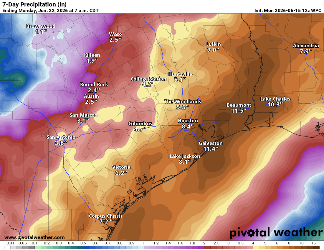
Forecasters warned that the situation could worsen again Tuesday morning after a brief lull. The National Weather Service said parts of Southeast Texas could receive more than 10 inches of rain by Thursday morning if storms keep tracking over the same areas.
Roads and rescues
High water blocked parts of Interstate 45 and U.S. 290 during the afternoon storm cycle, according to Houston Chronicle live coverage. The same reporting said stranded vehicles were seen and at least one water rescue was carried out on the North Freeway near Mount Houston.
Rainfall rates in some of the strongest storms were reported at 2 to 5 inches per hour, a pace that can overwhelm drainage quickly and turn roadways impassable. The threat was especially serious in Houston, where flat terrain, heavy pavement and fast runoff make flash flooding difficult to manage.
Airports and city response
The storms also hit air travel. Houston airports were seeing significant delays and cancellations, with more than 400 total flight delays reported in live coverage.
City officials said they were lowering Lake Houston, placing barricades in flood-prone areas and staging rescue vehicles and dump trucks. Houston police and fire crews were among the agencies preparing for additional calls as rain continued.
What forecasters are watching
The flood watch remained in effect through Thursday morning, and officials said the event was still unfolding late Monday with no all-clear or formal downgrade.
A brief lull overnight was expected, but the latest guidance pointed to heavier storms returning early Tuesday. That raised the risk of renewed street flooding, more road closures and additional rescue operations after dark.
A tropical disturbance near the Texas coast could also add to the rainfall risk later this week. Forecasters said it may help sustain the broader Gulf moisture pattern feeding the storms over Southeast Texas.
For now, the key questions are whether the overnight break holds, whether more roads or neighborhoods become vulnerable, and whether airport delays ease if rainfall briefly tapers off.
Revision note
Expanded with verified chronology, response details and forecast context.