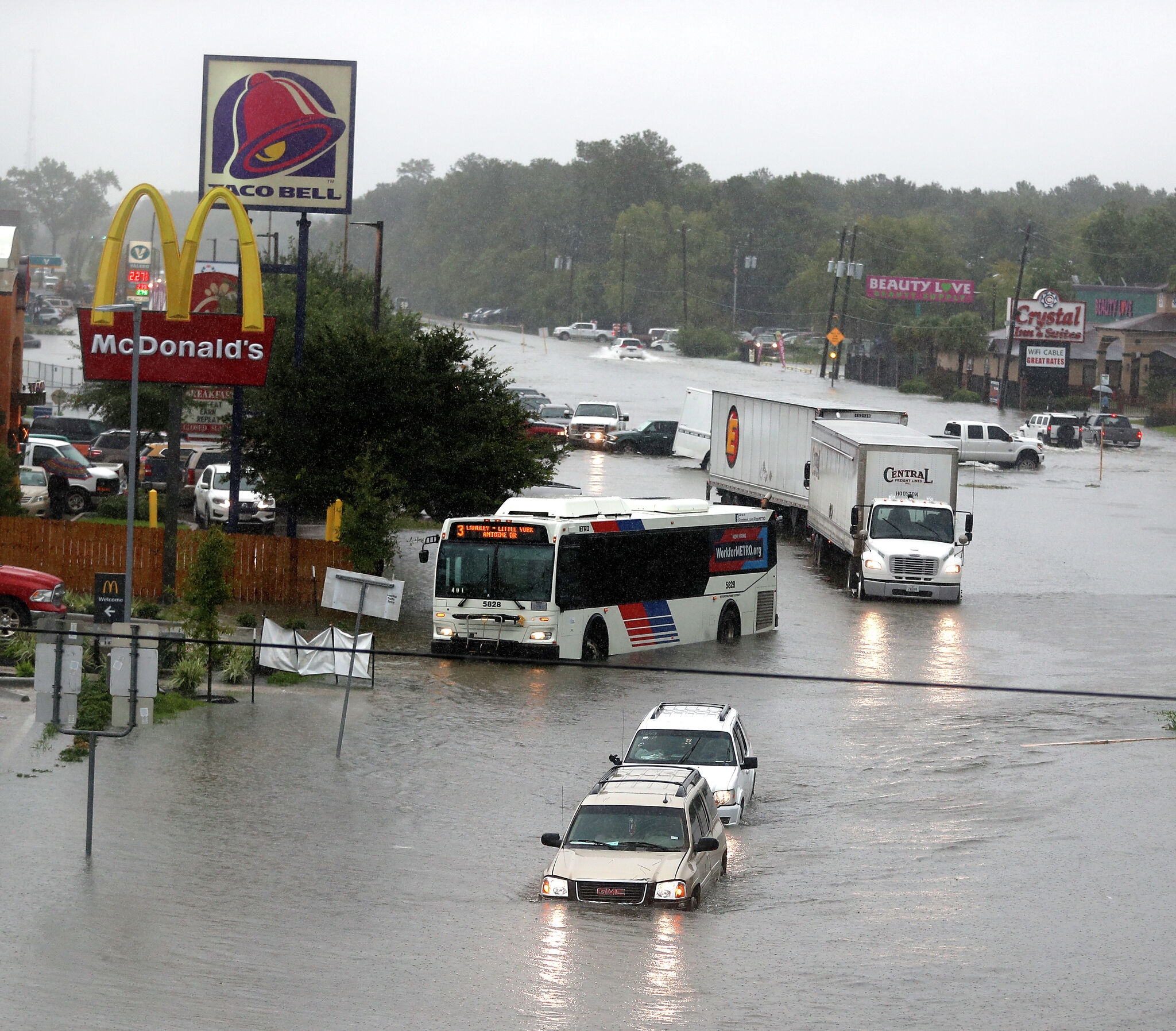
A developing tropical system near the Texas coast triggered flash flood warnings Tuesday for parts of northern Harris County and southern Montgomery County, including The Woodlands, Tomball and Oak Ridge North, as forecasters warned of rapid flooding, additional heavy rain and coastal hazards through midweek.
Flash flood warning north of Houston
A developing tropical system near the Texas coast triggered flash flood warnings Tuesday for parts of northern Harris County and southern Montgomery County, including The Woodlands, Tomball and Oak Ridge North.
The National Weather Service office in Houston-Galveston warned that rapid flash flooding was possible in the warned area. Coverage said some spots had already seen 3 to 5 inches of rain, with rainfall rates of 2 to 5 inches per hour in the heaviest bands.
Jeff Lindner, who was cited in local coverage, said rapid flash flooding was likely. The warning came as rain continued to fall over already vulnerable parts of Southeast Texas.
Tropical system takes shape
The same day, the National Hurricane Center issued its first advisory on the system, which coverage described as Potential Tropical Cyclone One near the Texas coast.
Earlier reporting said the disturbance was organizing near Corpus Christi and was expected to bring multiple rounds of heavy rain to the Houston area. Forecasters said the broader flood threat could last through Thursday morning.
Houston Chronicle reporting said the most dangerous period for the Houston area was expected Tuesday night into Wednesday morning. That same coverage said isolated rainfall totals could reach 10 to 15 inches in the hardest-hit bands.
Other local reports cited a forecast of 4 to 8 inches of rain overall, with isolated areas possibly receiving 10 to 12 inches.
Local impacts already showing up
The weather system was already affecting travel. Coverage reported at least 56 flight delays or cancellations at George Bush Intercontinental Airport as rain and poor conditions spread across the region.
Axios also reported local preparations ahead of the heavy rain, including Lake Houston being lowered and CenterPoint Energy mobilizing in response to the threat.
The flood concern is especially acute in urban and low-lying parts of the Houston area, where repeated rounds of rain can quickly overwhelm drainage and send water into streets, neighborhoods and bayous.
Coastal and marine risks
The threat was not limited to inland flooding. Coverage said tropical storm watches were in effect for Galveston Bay and the upper Texas coastal waters.
Forecasters also warned about stronger winds, rough marine conditions, tropical funnels and waterspouts if the system organizes further.
The main question now is whether the disturbance strengthens into a named tropical storm and where the heaviest rain band sets up. Another concern is whether warnings expand beyond northern Harris County and southern Montgomery County.
Residents and travelers across Southeast Texas are being urged to monitor updates closely through midweek, especially as the heaviest rain is expected to persist into Wednesday and possibly Thursday morning.
Revision note
Initial automated publication with fuller verified coverage.