Connecticut is entering a multi-day heat wave starting Wednesday, with inland highs in the 90s, heat index values above 100 degrees and the hottest conditions expected Thursday and Friday. Gov. Ned Lamont has activated the state’s extreme hot weather protocol, cooling centers are opening and forecasters say some cities could approach daily records.
Connecticut is entering a dangerous multi-day heat wave Wednesday, with forecasters warning that parts of the state could feel hotter than 100 degrees.
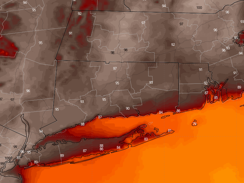
Inland communities are expected to reach the mid to upper 90s, while some shoreline towns may climb into the lower 90s. Humidity will push heat index values above 100, and the National Weather Service has issued Extreme Heat Warnings for parts of Connecticut through Saturday.
The state’s hottest stretch is expected Thursday and Friday. CT Insider reported that Hartford could reach 101 degrees, which would challenge a daily record from 1966, and Bridgeport could also come close to a record on Friday.
Warm nighttime lows in the 70s will limit relief after sunset. That matters because overnight cooling is one of the main ways the body recovers during prolonged heat.
State response
Gov. Ned Lamont activated Connecticut’s extreme hot weather protocol starting at noon Tuesday, before the most intense heat arrived. The state response is aimed at reducing risk for residents as temperatures climb and the heat index rises.
Municipalities, including New Haven, are opening cooling centers. CT Insider reported that libraries and senior centers are among the public spaces being made available for residents who need a place to get out of the heat.
The heat wave is part of a broader stretch of dangerous weather across the eastern United States during the July Fourth week. AP reported that humidity is driving heat indexes as high as 115 degrees in some areas outside Connecticut.
What to watch
Forecasters say thunderstorms remain possible during the heat wave, including isolated afternoon storms Wednesday and additional thunderstorms later in the week. Those storms could briefly worsen conditions with lightning, gusty wind and scattered outages.
Power demand may also rise as households and businesses use more air conditioning. That can add pressure to the grid at the same time public-health officials are trying to keep vulnerable residents safe.
Older adults, children, outdoor workers and people without air conditioning face the highest risk of heat illness. The danger rises further when heat index values stay above 100 and nights do not cool off much.
The next few days will depend on updated National Weather Service warnings, any county-by-county changes and whether temperatures actually reach record territory in Hartford, Bridgeport or elsewhere. Officials are also expected to keep adjusting cooling-center access as the week unfolds.
Revision note
Initial automated publication.